

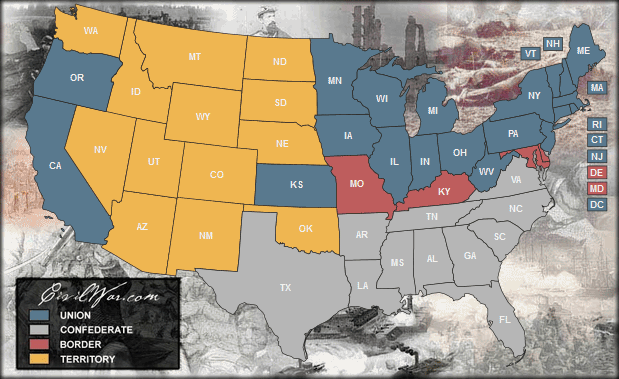
Major Battles of the Civil War
Latest News
- March is Women's History Month! Read the fascinating accounts of women spies hiding coded messages in women's hair, conductors of the Underground Railroad, soldiers disguised as men, surgeons, and advisors to the President!
- Confederate President Jefferson Davis calls for March 27 to be a day of fasting, humiliation, and prayer.
- Following the Underground Railroad Route By Bicycle
- Teachers tackle race, economic disparity and history
- The President's Hymn: 'Give Thanks All Ye People'
- Lincoln’s Thanksgiving proclamation in a divided time: ‘one heart and one voice by the whole American People’
- Thanksgiving Day during the Civil War
- What Abraham Lincoln found reading the Book of Job amid civil war
- Civil War stories on display at Lincoln Highway museum in Unity
- Who was Henry Benning, for whom Fort Benning in Columbus was named?
- Fort Gordon Army Base: Who was John Brown Gordon?
The US American Civil War
The US American Civil War was the greatest war in American history. 3 million fought - 600,000 paid the ultimate price for freedom. And a war for freedom it was. The desire for freedom traveled deeper than the color of skin and farther than the borders of any state.
There are hundreds of thousands of pages of information available through this site. Peruse the Official Record of the war, check out the Battle Map, or view the largest collection of Civil War photos available online.
--Official Record (Union Letters, Orders, Reports)
"...I know that the Lord is always on the side of the right; but it is my constant anxiety and prayer that I and this nation may be on the Lord's side."
The first general order issued by the Father of his Country after the Declaration of Independence indicates the spirit in which our institutions were founded and should ever be defended: "The general hopes and trusts that every officer and man will endeavor to live and act as becomes a Christian soldier defending the dearest rights and liberties of his country."
"We are not fighting for slavery. We are fighting for Independence, and that, or extermination"
-- Jefferson Davis
""If ye love wealth greater than liberty, the tranquility of servitude greater than the animating contest for freedom, go home from us in peace. We seek not your counsel, nor your arms."
-- Samuel Adams
"What is it that gentlemen wish? What would they have? Is life so dear, or peace so sweet, as to be purchased at the price of chains and slavery?"
-- Patrick Henry
